Storms which recently ravaged Britain's coastline have revealed 2,000-year-old footprints on an Angus beach - one of only a handful of locations in the UK where markings of this kind have ever been discovered
The imprints of human and animal feet – made around the time of Boudicca, Jesus, and the height of the Roman Empire – were temporarily revealed by shifting sands at Lunan Bay and spotted by vigilant members of the public.
Lunan Bay locals Ivor Campbell and Jenny Snedden were walking their dogs Ziggy and Juno along the picturesque sands when they saw that storm damage to the dunes had revealed a fresh layer of clay in which Ivor noticed distinct markings.
He called council archaeologist Bruce Mann who, suspecting both the significance of the discovery and the race against time they faced to capture it – called in expertise from the University of Aberdeen.
A team of archaeologists led by Professor Kate Britton dashed to the scene – picking up essential supplies like Plaster of Paris in a craft store enroute.
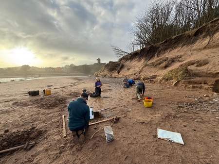
The team, including a group of faculty staff and PhD students, worked in windspeeds of more than 55mph while being battered by whipped up sand to preserve evidence of the footprints. Similar markings have been identified in small numbers of sites in England including the Severn Estuary, Formby in Merseyside, and Happisburgh in Norfolk, but there is no previous record of a similar site in Scotland.
Professor Britton said: “We knew we were dealing with a really rare site and that this discovery offered a unique snapshot in time – but it was also clear that the sea would soon take back what had so recently been revealed.
“We had to work fast in the worst conditions I’ve ever encountered for archaeological fieldwork - the sea was coming in fast, with every high tide ripping away parts of the site, while wind-blown sand was simultaneously damaging it. We were effectively being sand-blasted and the site was too, all while we were trying to delicately clean, study and document it, so it became a race against the elements. And, within 48 hours the entire site was destroyed.”
With Jenny and Ivor chipping in carrying buckets and catering very welcome tea breaks, the small team of archaeologists – which included Professor Gordon Noble, post-doctoral researchers Dr Will Mills and Dr Elinor Graham, and PhD students Sarah Barakat, Thomas Warrington and Tayla Sanders – were able to record and map the site, and capture 3D models and physical casts of the prints. Back in the laboratory, they selected preserved plant remains found in deposits just below the footprints for radiocarbon dating, which has recently confirmed the markings were made around 2,000 years ago. Ongoing analysis of the footprints has identified red deer, roe deer and other animals, as well as humans who would have walked barefoot on the now semi-fossilised clays.
“This is a real tangible link to the region’s past,” team member Professor Noble added. “The late Iron Age dates are in keeping with what we know about the rich archaeology of nearby Lunan Valley. It’s very exciting to think these prints were made by people around the time of the Roman invasions of Scotland and in the centuries leading up to the emergence of the Picts.”
Archaeologists say the unique find offers a window into human activity along the Angus coastline and the changing nature of the landscape.
Dr William Mills added: “It is incredibly rare to see such a delicate record saved, taking only minutes to create and hours to be destroyed, a snapshot of what people were doing thousands of years ago. The site also tells us how this now sandy beach was once a muddy estuary and that humans were using this environment, perhaps for hunting deer or to collect wild plant foods such as samphire.
“While this site was very short lived, it demonstrates the potential for similar finds – any of the clays of the wider Montrose basin area could preserve more of this important archaeological information.”
Professor Noble, along with Dr Mills and Dr Graham, was able to capture precious drone footage of the site in the rare moments the wind died down.
Dr Elinor Graham added: “The logistics of recording this exceptionally fragile site were very challenging but in small windows of calmer conditions, we took the opportunity to fly the drone and capture the site from the air. The photos let us map the footprints in 3D with millimetre accuracy as a permanent record, even though the site has now been lost. With sea levels rising and coastal erosion accelerating around Scotland it’s more important than ever that local community members keep an eye on their local coasts and report potential new discoveries.”
The drone images will help establish a baseline for examining the rate of erosion of this part of the coast, and the risks to other potential sites.
Bruce Mann, Regional Archaeologist serving Aberdeenshire, Angus, Moray and Aberdeen City Councils, praised the quick thinking of Ivor and Jenny in enabling analysis of the site to take place.
He said: “As soon as I saw the first photograph, I realised I was looking at something very special. It was a powerful reminder that some of the most important discoveries start with someone noticing something and choosing to report it. What came next was a race against time, and I cannot thank the University of Aberdeen team enough for responding to my call for help.
“Standing there, watching the site being destroyed as the waves crashed over it, was heartbreaking in some ways, but at least we got the chance to record most of it. There is nothing left now, the storms having both revealed and then destroyed the site in just over a week.”