The geology of the Rhynie area was originally mapped and described by Geikie in 1878 with further work by Wilson and Hinxman (1890) and Read (1923). The most recently revised map was published in 1993: BGS Sheet 76W. However, it has only been in recent years following the drilling programmes undertaken by the University of Aberdeen that the geology and particularly the sedimentary succession or lithostratigraphy is better constrained (Rice et al. 2002).
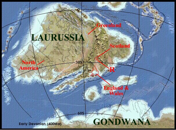
The sediments which host the Rhynie chert, as mentioned in previous pages, are Early Devonian (Pragian) in age and form a small part of what is commonly known as the Old Red Sandstone or ORS. The ORS comprises a sequence of continental sediments deposited by streams, rivers and lakes throughout the Devonian Period when Scotland, much of northern Europe, Greenland and North America formed a large continent called Laurussia or the 'Old Red Continent', located between 0o and 30o south of the equator. During the Early Devonian (Pragian) the Rhynie area was situated in the subtropics around 28o south of the equator (see inset below).
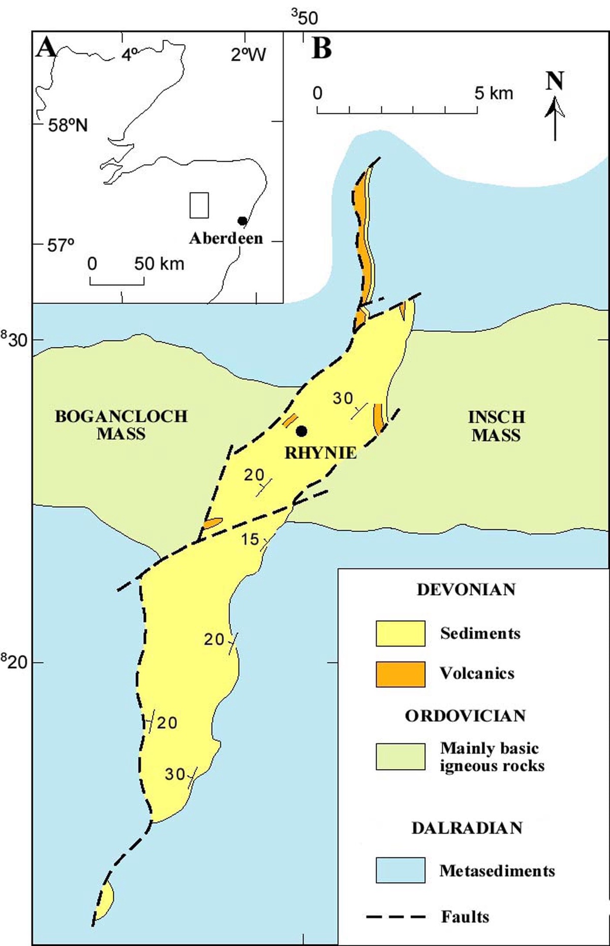
The basin in the south and the northern most region is a half graben, the western edge marked by a low angle (at the current level of erosion) extensional fault system which was active at the time of deposition during the Early Devonian (see below), whereas at the eastern edge of the basin the sediments lay directly on the basement rocks, the contact representing an unconformity. The central to northern area, containing the Rhynie chert locality is now believed to represent a completely fault-bounded strike-slip basin caused by regional trans-tensional forces (Rice and Ashcroft in press). Within the basin the sedimentary rocks are tilted, generally dipping towards the northwest, though the chert-bearing rocks in the area to the northwest of Rhynie village are folded into a syncline, the axis apparently plunging to the northeast.
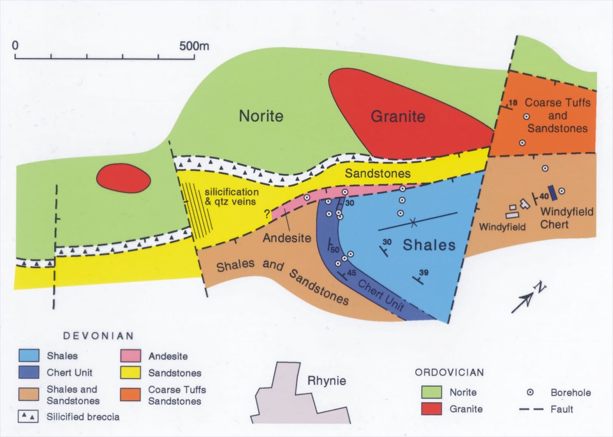
The cherts are associated with shales and sandstones towards the top of the sedimentary succession and are only known to occur in situ in the vicinity of the village of Rhynie itself, quite close to the faulted western margin of the basin (see inset below). Results from the drilling programmes suggest much of the sedimentary succession here is heavily disrupted by faulting, with the area being divided into a number of small faulted blocks along the main fault zone. The main features including the sedimentology and lithostratigraphy are described below.
- The Boundary Fault
-
- The Basin Fill
-
There is a variety of rock types that comprise the fill of the Rhynie basin including primarily sedimentary rocks (mainly sandstones and shales) and volcanic rocks. Traditionally the sequence of rocks has been divided into three main lithostratigraphic units: the Tillybrachty Sandstone, Quarry Hill Sandstone and Dryden Flags formations; the latter unit in the Rhynie area hosting the cherts (see inset below). See Rice et al. (2002) for details of the stratigraphy. Click on the formation names in the inset below for an outline of the lithologies encountered in each and their inferred environments of deposition.
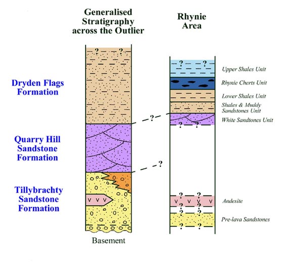
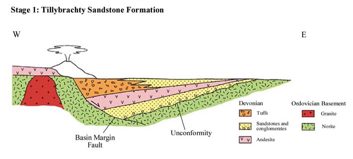
Tillybrachty Sandstone Formation This lithostratigraphic unit comprises the lower part of the sequence of the basin fill and is laterally variable in character. In much of the basin the unit is dominated by coarse-grained clastic rocks, primarily locally derived sandstones and conglomerates. In the area of Rhynie itself much of the unit appears to comprise a significant thickness of tuffs with interbedded sandstones (Rice et al. 2002). Some of the tuffs appear to represent direct air-fall deposits, but most appear to have been water-lain and were probably derived from eroding ash cones.
The sedimentary rocks of the Tillybrachty Sandstone Formation appear to represent localised deposition in an alluvial environment. The conglomerates and coarse-grained sandstones were probably initially deposited as alluvial fans at the basin margins with sediment being distributed further into the basin by sheet flood events. Localised volcanic activity is also evident by the presence of andesitic lava flows and tuffs.
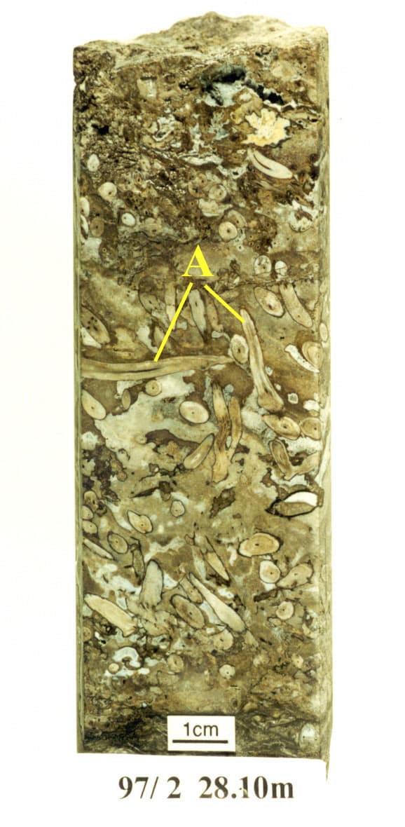
Quarry Hill Sandstone Formation This lithostratigraphic unit succeeds the Tillybrachty Sandstone Formation. It occurs throughout much of the basin and is particularly distinctive in the south west of the area where it outcrops in the disused sandstone quarries on Quarry Hill (see inset below). This formation primarily comprises stacked, well bedded, current rippled, laminated and cross-stratified sandstones rich in feldspar grains. In this particular area these sandstone beds form large-scale channelised deposits commonly exhibiting erosive bases with mud rip-up clasts and are occasionally interbedded with scoured thin shale horizons.
In the Quarry Hill area the sandstones locally yield casts of transported plant debris, some of which are particularly large (see inset below).
Of these plant remains, and perhaps one of the most enigmatic, may tentatively be assigned to the genus Prototaxites (belonging to an extinct group of Palaeozoic plants called the nematophytes). When the area was actively being quarried in the late 19th and early 20th centuries, these plant fossils were occasionally found in the form of logs preserved as sandstone casts. One specimen, recorded by Newlands (1913) as "a plant fragment" and nearly 1.3 m in length, is now housed in the collection of the Department of Geology and Petroleum Geology, University of Aberdeen (see inset below).
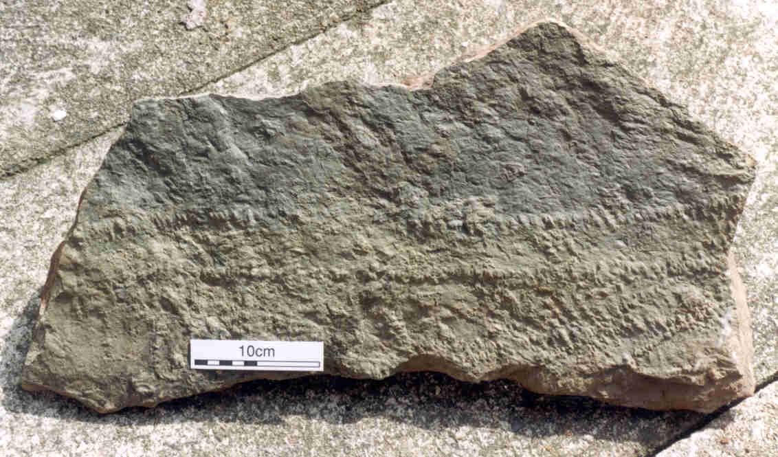
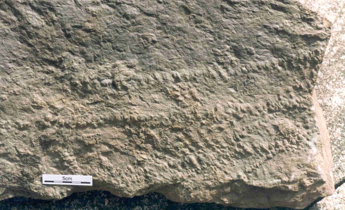
Trace fossils have also occasionally been found on bed surfaces including Diplichnites, a preserved trackway about 5cm wide, probably created by a large myriapodous arthropod (see inset below).
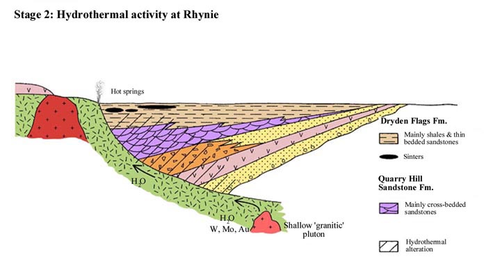
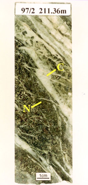
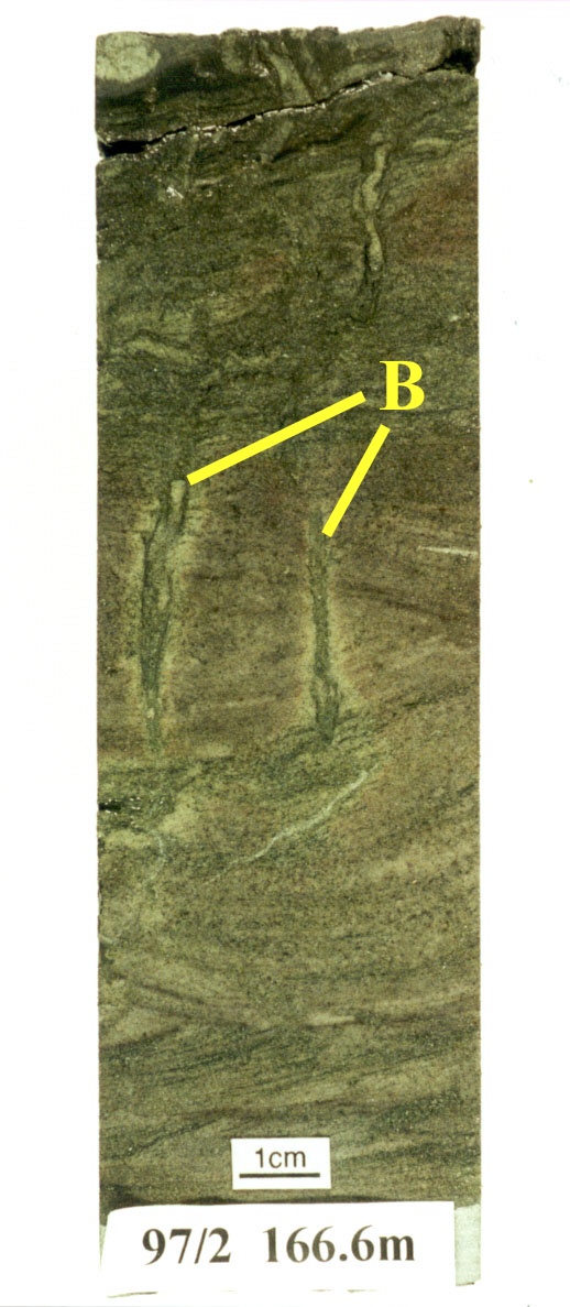
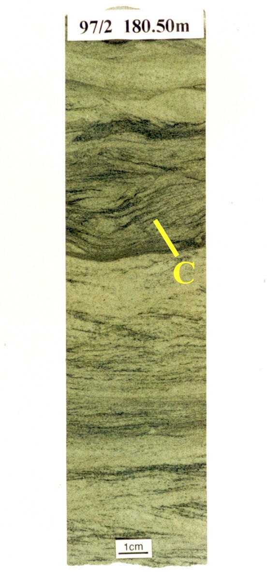
The "White Sandstones Unit" encountered in Borehole 97/2, north west of Rhynie village, is a 50m interval of hydrothermally altered white, laminated, rippled and cross-stratified sandstones with minor shale interbeds. It is thought to represent at least part of the formation in this area (see insets below). Locally the sandstones are heavily cemented by calcite. In this borehole its basal contact is with a hydrothermal breccia above the main fault zone and, with increasing shale content, passes upwards into the more mud-rich beds of the Dryden Flags Formation explained below.
Typical features of the White Sandstones Unit in Borehole 97/2
The overall environment that seems to be represented by this unit is one dominated by shallow fluvial channels of a river system flowing towards the northeast along the axis of the basin. The occasional shale horizons may in part represent poorly preserved overbank and floodplain deposits.
The lateral change from the more stacked, well-bedded sand-rich lithofacies at Quarry Hill to the dominantly thinly bedded sands and minor shales in the area northwest of Rhynie village suggests the presence of larger-scale fluvial channels in the Quarry Hill area.
Dryden Flags formations The Rhynie cherts occur within the Dryden Flags Formation which forms the upper part of the of the sequence of the basin fill. It is a sequence of thinly bedded micaceous sandstones (traditionally termed 'flags') and shales, that were previously recognised as the Dryden Flags and Shales and in part may represent a lateral equivalent to the Quarry Hill Sandstone Formation (see Rice et al. (2002) for details of the stratigraphy described below).
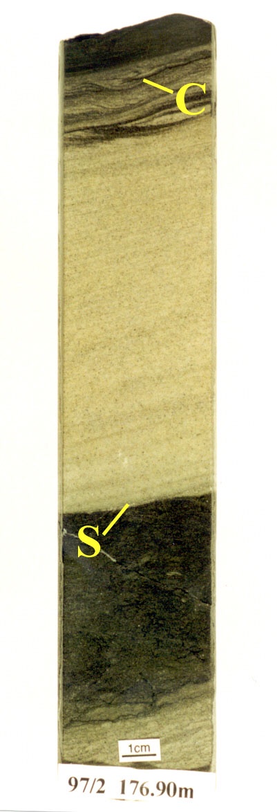
The succession of the Dryden Flags Formation in the Rhynie area, following the drilling programmes by the University of Aberdeen and recent studies, can now be divided lithologically into four discrete units. The lowest unit, informally termed the "Shales and Muddy Sandstones Unit" grades up from the "White Sandstones Unit" below and comprises primarily thickly bedded (up to 1m thick), erosively based massive muddy sandstones interbedded with thin shales and siltstones which show abundant soft-sediment deformation features. This unit passes upwards into a thick sequence of dark shales with thin fluidised and disrupted sand and silt laminae, informally termed the "Lower Shales Unit" (see inset below left).
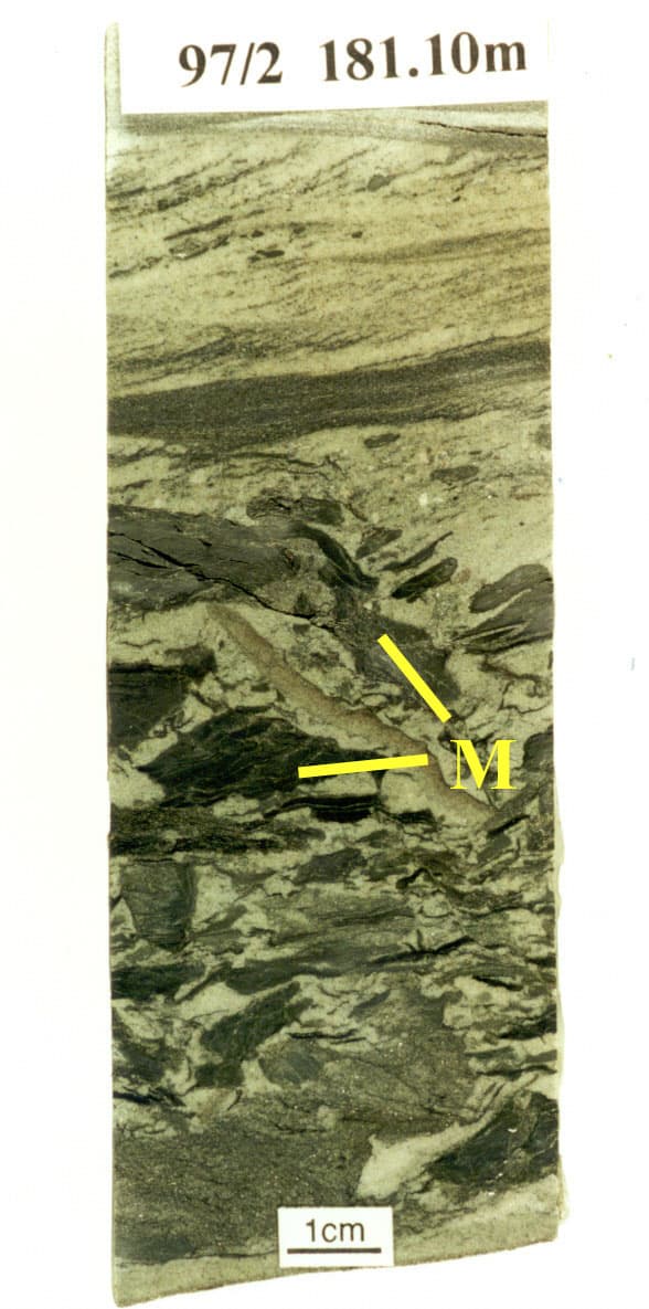
Above the shales lies the chert-bearing part of the sequence, informally termed the "Rhynie Chert Unit". Comparing borehole and trench data the chert beds (see inset above right) are laterally impersistant (Trewin & Wilson 2004). One borehole (19c) studied by Clare Powell exhibited 53 individual chert beds over a depth interval of 26m, many of which are plant-bearing (Powell et al. 2000b) (for a more detailed review of the chert morphologies and textures see the following section on Chert Textures). The chert horizons are variably interbedded with silicified compacted sandstones with organostylolites, together with thin shales and siltstones similar in lithology to the units below and above. By comparing the biota content and textures of the discontinuous plant-bearing chert beds of the Rhynie Chert Unit with Recent plant-bearing sinters and modern hot spring environments at Yellowstone National Park, USA, Trewin and Wilson (2004) suggest that much of the Rhynie chert succession represents sinter deposition on the distal, cooler reaches of a hot spring outwash apron.
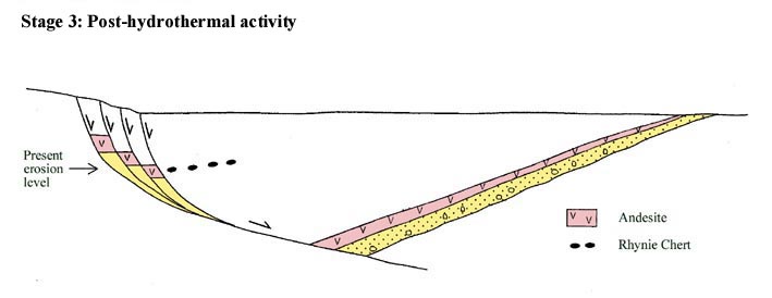
The uppermost lithological unit in the Dryden Flags Formation is informally termed the "Upper Shales Unit" and is at least 13m thick. It comprises primarily green-coloured laminated shales (locally exhibiting desiccation cracks) variably interbedded with impersistant thin sandstone beds that often display sharp to erosive bases, mud rip-up clasts, current ripple laminae and graded bedding. Patchy calcite cementation is present in the sandstones. Similar lithologies host the Windyfield chert, some 700 m to the northeast of the Rhynie chert locality, and therefore it has been suggested the Windyfield chert probably occurs within this younger unit (Rice et al. 2002; Rice & Ashcroft in press).
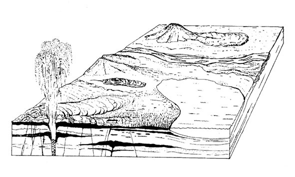
The overall environment represented by the rocks of the Dryden Flags Formation appears to be an alluvial plain setting with mainly overbank deposition on floodplains and in ephemeral lakes with occasional sheet-flood events. The cherts and their interbedded sediments representing localised deposition of subaerial and subaqueous sinters from hot spring and geyser activity and the accumulation of soils on floodplains (see inset below).
- Basin Evolution
-
The Rhynie basin was formed as a result of trans-tensional forces affecting the Dalradian metamorphic and Ordovician igneous rocks in the northeast Grampian area following the closure of the Iapetus ocean. Based on present knowledge (Rice et al. 2002) the evolution of the Rhynie basin can be described in diagrammatic form.