| |
THE
PHOTOALBUM AND GRAPHIC IMAGES OF THE POLAR CENSUS EXPEDITION
TO SIBERIAN TERRITORY 1926-1927
Overview
This CD-ROM edition is a digitised version of a rich collection of photographs
and drawings housed in the archive of the Krasnoiarsk Territorial Museum.
These images were compiled in 1928 from glass-plate photographs and paintings
done during the 1926-1927 Polar Census expedition. These high-quality
images give us a unique insight into the lives of Evenki, Dolgan, Ket,
Enets, and Nenets people at a time before the social policies of the Soviet
state transformed their economies. The photographs and paintings also
reveal the interests and scientific interests of the 13 young enumerators
who took part of the expedition. Unlike most censuses, which in the end
result in very dry lists of tabular data, this album gives us a very rich
insight into the lives of people, and the enumerators who questioned them,
at a very important date.
The CD-ROM edition is intended to give the reader access to the images
by census district and by the name of the enumerator. The disk is also
structured such that the images can be viewed in the original more-or-less
random order in which the album was composed. These two search parameters
allow the reader to look at the images beside the primary written records
of the census, which will also be published in a separate DVD edition.
Context
The 1926-1927 Polar Census was an ambitious undertaking of the young Soviet
state. Its goal was to gain a deep overview of the cultures of the native
peoples of Siberia. Conceived originally as part of the 1926 All-Russian
Census, the this census provided extremely detailed records on all of
the nomadic native peoples, many of whom at this time still lived independently
from Soviet Power. In contrast to the general census, the polar census
workers set themselves the goal the documentation of every aboriginal
household. In addition, the Central Statistical Administration (TsSU)
recruited experienced fieldworkers from the famous Committee of the North
and from the Russian Society of the Red Cross to undertake the survey.
Because of the energy and zeal of many of the younger members of the census,
much of the primary records go well beyond what we understand today as
statistics and represent a form of ethnography and social geographical
analysis. Most enumerators kept field diaries, took photographs, and wrote
detailed marginal notes on their census records that represent a form
of ethnography. Indeed, many of the census enumerators later became professional
ethnographers, geographers and biologists; building on their fieldwork
to create an impressive bibliography of scientific literature. The quality
and the scale of the material derived from this census, in international
terms, outshines any other type of social, ethnographic, or geographic
analysis done at this early date in any of the countries of the circumpolar
Arctic. The primary field records of the polar census present a valuable
insight into the lives of Siberian peoples, which is of value to circumpolar
aboriginal peoples generally.
Although the Polar Census was implemented at a level of great detail,
its data were never used to their potential. By the time that the records
were collated and analysed from 1929 to 1934 the mood of the Soviet state
turned from one of exploring ethnic and cultural difference to identifying
possible sources of counter-revolution. A series of articles in 1933 and
1934 criticised the Polar Census for not being sensitive enough to class
analysis, and the primary materials were filed away to serve as background
archives for territorial formation (zemleustroitelnye) expeditions and
for ethnographers who knew of their existence. The published results of
the census confined themselves to a demographic summary of the numbers
of people living in Siberia as broken down by ethnicity, language, and
ownership of key capital resources such as reindeer.
The goal of this project is to collect, catalogue, and duplicate key parts
of the Siberian Territory (Territory) Polar Census expedition, making
them widely available to scholars. The project uses modern digital photographic
techniques in archival work to create copies of the primary material of
this branch of the census. This technology allows scholars, for the first
time, to read documents pertaining to specific communities without having
to travel to different cities across the Russian Federation. It also allows
scholars to search the records along various standard criteria to discover
which records are available for particular places, or particular peoples.
The project was conceived and funded by the ethnographic context module
of the Baikal Archaeology Project, based at the University of Alberta
(Canada) and the University of Aberdeen (Scotland), as our contribution
to creating an archive of material which allows scholars worldwide to
understand the complex ecological of hunters and reindeer herders in the
circumpolar north. The cataloguing and photography of census documents
was funded by the Social Sciences and Humanities Research Council of Canada
(SSHRCC MCRI 412-2000-1000). The scanning and cataloguing of glass negatives
and photographs was funded by the British Academy (BA SG-3555). The project
facilitated through the generous support and hard work of archivists in
the following archives:
State Archive of Krasnoiarsk Territory [GAKK]
State Archive of the Russian Federation [GARF]
Krasnoiarsk Territorial Museum of Regional Lore [KKKM]
National Archive of the Sakha Republic (Yakutiia) [NARS]
The
Organisation of the Image Collection
The heart of this collection is a digital representation of a single photoalbum
which was discovered recently in the document collection of the Krasnoiarsk
Territorial Museum (KKKM 7930 б-ф 1) . The original photoalbum is an extremely
large book (approx 70 cm x 40 cm) of black, firm paper onto which 12-15
photographs had been pasted on each side. The album has 25 pages, and
is bound in a dark brown leather binding with the name Polar Census Expedition
embossed prominently on the cover. The pages have become unbound from
the album. The album features 513 small black and white prints, many of
which are annotated with a short title and the initials of the person
who took the photograph. This particular CD contains more images than
the original photo album. During our research into the history of the
expedition, our archive workers also discovered the original paintings
and sketches by A.P. Lekarenko (as pictured in the photo album). We have
chosen to include the entire collection of Lekarenko images, which includes
7 drawings not originally reproduced in the photo album. In addition,
our research turned up a collection of glass-plate negatives linked to
the collection. Fifty of these plates were identified as belonging to
the expedition. Scanned versions from the negatives have been included
in the collection. Our intention is to create a research tool which not
only gives a digital representation of this unique album, but also provides
a convenient source for all of the graphic work done during the Polar
Census expedition.
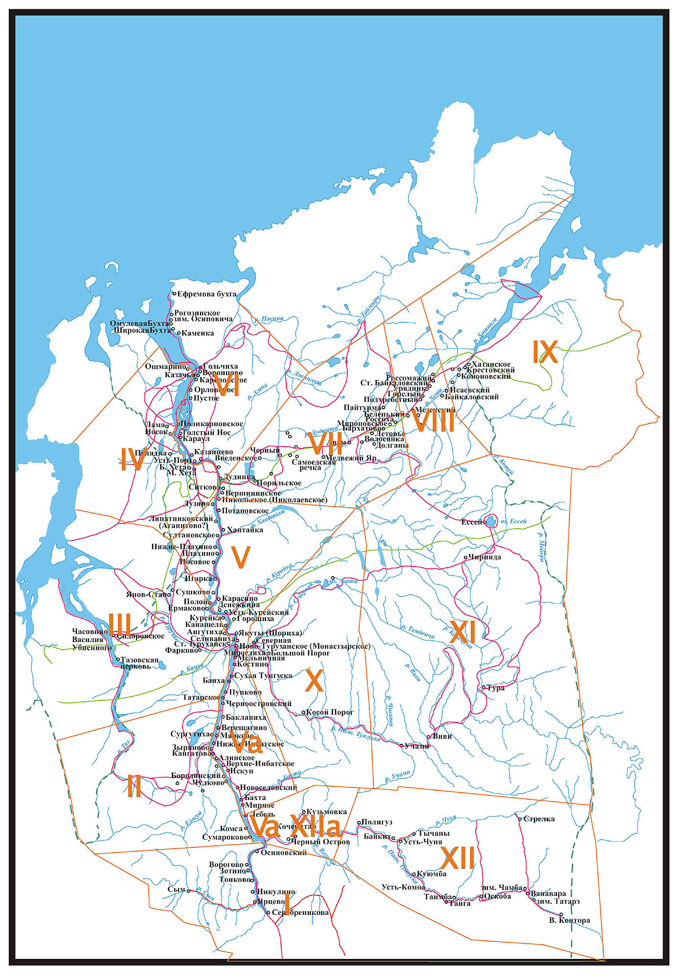
Enumerators spent up to a year travelling to different communities within
15 census districts.(Illustration
1)
These
districts were indicated with roman numerals. Their boundaries were determined
by regional administrative officials who had experience with collecting
Tsarist yasak from families in previous years when the yasak system was
still in place.
The geography of the census districts (участки) has caused our team a
lot of confusion, and it is important for readers to understand how it
worked. At the beginning of the census expedition in the summer of 1926
the census districts were described according to essentially Tsarist yasak
designations and on the basis of the work by Dobrovo-Yadretseva (1925).
These tended to describe the habitual paths by which the state would expect
to encounter native people. Over the year that the census was in progress,
the entire territory was divided up into an early Soviet territorial administrative
system wherein pre-existing guberniia were created into okrugy. Okrugy
in turn were sub-divided into volosti. The organisation of the census
material into the new system occurred in many cases after the fieldwork
was over. As a result, one often finds older administrative-territorial
designations written on the actual documents. For the census in Siberian
Territory, the new 1927 system was indicated with a roman numeral marked
on each card in a thick red marker. This roman numeral is different from
roman numerals used to indicate the 1926 census districts. At the same
time a new way of numbering communities was also applied. Thus our team
has had to struggle with two different numbering systems in trying to
discover how thousands of documents fit together. To make matters more
difficult, some areas (such as the Podkamennaia Tunguska and Angara River
Valleys) were not yet classified by Soviet influence by 1927 and were
described only with the paradoxical name as the non-classified district
(vnevolostnaia volost’).
When the census material was published, each of the local volosty were
once again renumbered into a federal system which reduced the total number
of units. The new map appears in the publications of the Central Statistical
Administration of 1929 (TsSU 1929). In working with the documents it is
important to keep track of all of these changes. The following table gives
the main parameters:
1928
№
волость |
1929
№
волость
|
1928
District Name |
Older
Names |
1926
№ участок |
| I |
21 |
Верхне-Инбатская
волость, Туруханский Край, Красноярский Оркуг |
|
I,Va,VI,
XIIа |
| II |
24 |
Монастырская
волость, Туруханский Край, Красноярский Оркуг |
|
V,
Va |
| III |
22 |
Дудинская
волость, Туруханский Край, Красноярский Оркуг |
|
IV,
V, VI, VII |
| IV |
25 |
Тазовская
волость, Туруханский Край, Красноярский Оркуг |
|
III |
| V |
26 |
Хатангская
волость, Туруханский Край, Красноярский Оркуг |
Затундринский
район |
VII,
VIII, IX |
| VI |
23 |
Илимпейская
волость, Туруханский Край, Красноярский Оркуг |
|
X,
XI |
| VII |
27 |
Бассейн
Подкаменнно-Тунгуски, Туруханский Край, Красноярский Оркуг |
Вневолостая
волость |
XII |
| VIII
|
28 |
Усть-Кутский,
Макаровский, Приображенский, Чечуский, Казачинский районы, Киринский
Окрг |
|
|
| VIII
a |
29 |
Бодобадинский
и Качугский районы, Иркутский Округ |
|
|
| XII
a |
21 |
(Усть
Подкаменно-Тунгуской реки), Верхне-Инбатская волость, Туруханский
Край, Красноярский Оркуг |
|
XIIа |
| XV |
27 |
(водораздел
Ангари) Бассейн Подкаменнно-Тунгуски Туруханский Край, Красноярский
Оркуг |
|
XV |
When
trying to interpret these regional units in terms of the modern map of
Krasnoiarsk territory and of Irkutsk Oblast’, it is important to remember
that the external boundaries of these units have changed. The major differences
between the map of 1928 and that of 2004 is that at the start of the Soviet
period Tazovaskaia volost’ represents the present-day Turukhanskii raion
of Krasnoiarsk Territory as well as substantial territories in what is
now Tiumenskaia oblast’. It is also important to remember that the boundary
between Krasnoiarsk okrug and what was to become the Rebublic of Sakha-Yakutiia
had still not been determined.
There are further summaries of how the census was organised in the publications
of the census workers themselves (Kovalev 1928; Nagaev 1927; Kurilovich
& Sirina 1999; SKSO 1928).
On the main page of the CD-ROM, the reader can choose to search the collection
either by the name of the registrar, or by one of the 15 census districts.
The search page gives small, thumbnail images of the photograph with the
archival classmark and other information that accompanied the photograph.
Mikhail Batashev, through his research on the routes of the expedition
members, was successful in adding other information which allows one to
more exactly place the image. If one selects the image again on the search
page, the reader can choose two further resolutions to create a larger,
more detailed image.
Analysis
The photo album which forms the centre of this collection is one of four
photo albums created from the field photographs of the enumerators (ГАКК
1845-1-132; 769-1-480). The fate of the other three photo albums is not
clear, nor is it clear if all of the albums were identical. References
suggest that one album may have been sent to the Central Statistical Administation
in Moscow, and that another may have been proved to the head-office of
the Committee of the North in Novonikolaevsk (Novosibirsk). The Committee
of the North paid for the cameras and materials for the census expedition.
In 1929 a large museum exhibition on the peoples of Turukhansk Territory
was organised in Moscow at what was then called the Museum of narodovednie.
Records of the exhibition state that many photographs, as well as maps,
models, and folkloric texts were displayed (ГАКК 1845-1-132: 48). Whether
or not these materials were returned to Krasnoiarsk is not known.
Researchers should not omit the fact that the three Irkutsk-regions expeditions
which were considered to be part of the census for Sibirskii Krai also
returned with a wealth of photographs. These images were not included
in this particular photo album, but it is possible that the photographs
are stored in the Irkutsk Oblast Museum of Regional Lore (IOKM).
The fact that the census administrators had invested so much energy in
keeping a photographic record of Turukhansk region is in itself interesting.
The census director, A.P. Kurilovich, exorted his enumerators to record
as much material as possible about the lives of the indigenous people.
His letters and instructions encouraged enumerators to record rituals,
folklore, to make descriptions of the living environment of the native
peoples. Aside from the collection of photographs and drawings, the census
expedition left behind a rich record of diaries, and many qualitatively
rich census forms which record details about the nature of life in the
Turukhansk North.
Part of the region for this interest in the lives of native peoples comes
from a very deep regional tradition of gathering regional-lore (kraevedenie).
In the years preceeding the census itself, many scholars were active in
organising the documents which would be used in the census itself with
the aim of gathering ethnographic information on the region (ГАРФ 3977-1-310;
КККМ бф (изолатор) «материал к переписи»).
If the reader looks at the photographs in the order that they are presented
in the original album, he will gain a chaotic view of the material. The
immediate impression created is one of an immense travel diary where images
of landscapes overlap with personal photographs of the registrars themselves.
Interspersed within the collection are numerous photographs of Ket, Evenki,
Enets and Sakha people in what is now regarded as traditional costume,
engaged in hunting, fishing, and household activities. As with the photographic
collections of many ethnographers today, there are a high quantity of
pictures of children and of reindeer. This particular CD collection allows
the reader to look at the photographs as personal collections of each
registrar. When one does so, interesting themes emerge. The future artist,
A.P. Lekarenko, showed a great interest in textured landscapes, such as
the imposing escarpments of the Putoran plateau. He also showed a fine
interest in the details of costumes and ritual idols. The future ethnographer
B.O. Dolgikh took pictures of people, often using the standard physical
anthropological technique of photographing profiles. The future biologist
N.P. Naumov has one of the largest collections which gives great intimate
detail of the hunting and trapping lifestyle of people. In his collection
one can examine the architecture of tents and stable dwellings, examine
traps and tanning procedures, and see people engaged in their activities
out on the land.
Although the census records were never given the attention of state managers
that they deserved, it would be a mistake to think that they have not
been used in academic research. In the years immediately following the
census expedition dozens of studies appeared in ethnography, economics,
wildlife biology, public policy, and demography. Within ethnography, the
key works were published by B.O. Dolgikh who wrote on local concepts of
ethnicity in Taimyr (1929), Kets (1934), Nganasans (1938), authorised
identities among Dolgans (1963). His classic work which on ethnicity in
Siberia (1949) used census materials as their foundation. Within rural
economics and social geography the enumerators Kopylov (1928) and Samokhin
(1929) published fine community studies of the Kirinskii and Irkutskii
okrugs and the Siberian census chief himself wrote a fine overview of
Evenkiia (Kurilovich & Naumov 1934). Taresenkov (1930) used photographs
and statistics to provide an overview of Turukhansk Territory. The first
works describing Siberian reindeer husbandry also appeared at this time
(Dobrova-Yadrinteva 1927a; 1927b; Tan-Bogoraz 1932; Karger 1930; Kerletskii
1931; Maslov 1934; Tereletskii 1930). N.P. Naumov, who later became a
distinguished biologist, published is first works using observations he
gathered during the census (Naumov 1928;1930;1934). In public policy,
the census records were used initially to speak about the proper way to
draw borders (Sushilin 1929; Berezovskii 1930a, 1930b), the tragic subject
of the concentration of wealth (Skachko 1930a; 1930b; Suslov 1930). Finally
in demography, the census records were used in debates on whether or not
Siberian peoples were disappearing (Shneider & Dobrova-Yadrintesva
1928; Orlovskii 1932; Terletskii 1932; 1936).
After the initial period, and following the time that the Polar census
came under open criticism (Tan-Bogoraz 1932; Sergeev 1933) the number
of works published using the materials fell dramatically. However, the
primary records served and continue to serve as a rich source material
for ethnographers. As mentioned above, B.O. Dolgikh continued incorporating
the materials in his later publications. In 1952, the census records played
a prominent role over a debate on ethnicity in the Olenok region of Yakutiia
(Tereletskii 1951; Gurvich 1952). Recently, historians of ethnography
have been recovering works on the census to write about the foundations
of Soviet ethnography (Kuriliovich & Sirina 1999; Savolskul 2004).
The primary materials of the census, however, have enjoyed little circulation
internationally despite their quality which rivals that of other data
collections on circumpolar peoples. In Canada and in Alaska, an entire
discipline of ethnohistory has been founded upon the interpretation of
trade and census records as applied to indigenous peoples. The records
used by these ethnographers and historians tend to be fur-trade records,
such as those left by the Hudson’s Bay Company, or state treaty records
of specific Indian reservations (Biosli 1995; Krech 1991; Ray 1976; 1998).
As a rule, indigenous people do not appear in state censuses until very
late (the mid 1980s in Canada, for instance). The methods used to study
these periods are rather like those used by Russian historians to study
yasak registers. They tend to use crude multipliers to deduce population
numbers from one sack of flour sold, or one marten skin traded. Nevertheless,
these are the baseline studies used in English and French language studies
to make large generalisations about society and economy in the Americas
at the start of colonisation. The records of the Polar Census, by contrast,
are much more comprehensive and much detailed. Their analysis could bring
important comparative results in the field of ethnohistory.
Not least of all this material will become increasingly important for
indigenous peoples themselves as the revival of their national cultures
continues and they conduct new political negotiations with the large forestry,
gas, and diamond companies working on their territories. We hope that
this digital collection will encourage an intense interest in the lives
and cultures of the aboriginal peoples of the Yenisei North.
Bibliography
Березовский А.И. 1930. Как рационализировать рыбное хозяйство Туруханского
края. Советский север сборник статей. с. 71-160.
Березовский,
А. 1930. Земле-водо-устройство Сибирского Севера. Советский Север. No.
2: 50-73.
Тан-Богораз,
В.Г. 1932. Северное оленеводство по данным всесоюзной переписи. Советская
этнография. No. 4: 26-62.
Доброва-Ядринцева
Л.Н. 1925 . Туземцы Туруханского края. Опыт исследования экономического
положения. Новониколаевск.
Доброва-Ядринцева
Л.Н. 1927. К материалам по оленеводству Сибирского края. Труды Сибирского
Ветеранского Института. tom 8 : 249-269.
Доброва-Ядринцева.
1927. Оленеводство в экономике туземного хозяйства сибирских окраин. Жизнь
Сибири. No. 5: 53-63.
Долгих
Б.О. 1929. Население полуострова Таймыра и прилегающего к нему района.
Северная Азия. No. 2: 49-76.
Долгих
Б.О. 1934 . Кеты. Иркутск.
Долгих
Б.О. 1938 . Легенды и сказки нганасанов. Красноярск.
Долгих,
Б.О. 1949. Родовой и племенной состав народностей севера средней Сибири.
Краткие сообщения института этнографии. No. 5 (1): 70-85.
Долгих,
Б.О. 1963. Происхождение долган. В Кн. В. О. Долгих (отв. ред.) (ред)
Сибирский этнографический сборник 5. вып. 84 , Tom. Труды института этнографии
АН СССР (новая серия). с. 92-141.
Гурвич,
И. С. 1952. По поводу определения этнической принадлежности населения
бассейнов рек Оленека и Анабара. Советская Этнография. tom 2 : 73-85.
Каргер,
Н.К. 1930. Оленевоство у еницейцев (кетов). Советский Север. No. 6: 28-38.
Керлецкий,
С. 1931. Оленеводство в СССР и его перспективы. Советская Азия. Kn 1-2:
около 27.
Копылов
И. П. (ред) 1928. Тунгусское хозяйство Лено-Кириенгского края по данным
статистико-экономического обследования 1927 года. Кн. 58 Исследования
колонизационных фондов.
Ковалев,
Е.И. 1928. Приполярная перепись 1926-27 гг. в Сибирском Крае. Статистический
бюллетень (Новосибирск). No. 13-14: 214-226.
Курилович
А.П.; Н.П. Наумов. 1934 . Советская Тунгусия (Эвенкийский национальный
округ Восточно-Сибирского края). Москва, Гос. изд-во стандартизации и
рационализации.
Курилович,
А.П & А.А. Сирина. 1999. Отчет Туруханской статистической экспедиции.
Этнографическое Обозрение. No. 5: 144-159.
Маслов,
Павел. 1934. Кочевые обьединения единоличных хозяйств в тундре Северного
Края. Советский Север. tom 5 : 27-34.
Нагаев.
1927. Производство переписи в Туруханском крае. Статистический бюллетень
(Новосибирск). No. 11-12: 207-209.
Наумов,
Н. 1928. В Туруханском крае. Землеведение. tom 39 vyp. 4 : 28-62.
Наумов,
Николай Павлович. 1930. Промысловые млекопитающие Туруханского Края. Советский
Север. No. 3: 36-37.
Наумов,
Н.П. 1934. Охотхозяйство Севера во второй пятилетке. Крайний Север к 1934
г. Сборник материалов по хозяйственному и культурному строительству. с.
68.
Орловский,
П. 1932. Территория и население Крайнего Севера. Советский Север. tom
1-2 : 69-83.
Самохин,
А.Т. 1929. Тунгусы Бодайбинского района. Сибирская живая старина. vyp.
8-9 : 5-66.
Савоскул,
Сергей Сергеевич. 2004 . Начало пути: участие Б.О. Долгих в приполярной
переписи 1926-27 гг. Sibirica vol. 3 (2): in press.
Сергеев,
М.А. 1933. К вопросу о народно-хозяйственной переписи Крайнего Севера.
Советская Этнография. vyp. 3-4 : 9-28.
Сибирский
Краевой Статистический Отдел. 1928. Материалы приполярной переписи в Сибирском
крае. вып. 1. В серии: Список населенных мест
Скачко,
Антон. 1930. Имущественные показатели социальных групп у малых народов
Севера. Советский Север. No. 3: 5-28.
Скачко,
Антон. 1930. Классовое расслоение, меры борьбы с кулачеством и коллективизация.
Советский Север. No. 2: 38-49.
Сушилин,
Н. В. 1929. К вопросу о новой границе между приангарским краем канского
округа и районом Подкаменной Тунгуски. Советская азия. No. 3: 114-125.
Суслов,
И.М. 1930. Расчет минимального количества оленей потребных для туземеных
хозяйств. Советский Север. No. 3: 29-35.
Тарасенков,
Г.Н. 1930 . Туруханский Край. Красноярск, Туруханского РИКа.
Терлецкий,
П.Е. 1930. Основные черты хозяйства Севера. Советский Север. No. 9-12:
42-85.
Терлецкий,
П.Е. 1932. Народно-хозяйственная перепись Крайнего Севера. Советский Север.
No. 6: 5-10.
Терлецкий,
П.Е. 1932. Население Крайнего Севера (по данным переписи населения 1926-27
гг.). вып. 1-2 , Tom. Труды Научно-Исследевателскогой Асоциации Института
Народов Севера.
Терлецкий,
П.Е. 1936. Состав населения Крайнего Севера. Советская Арктика. No. 11:
36-41.
Терлецкий,
П.Е. 1951. Еще раз к вопросу об этническом составе населения Северо-Западной
части Якутской АССР. Советская этнография. No. 1: 88-99.
Центральное
Статистическое Управление. 1928. Всесоюзная перепись населения 1926 года:
Сибирский Край. Tom. 6. В серии: Отдел 1. Народность, родной язык, возраст,
грамотность
Центральное
Статистическое Управление; Смулевич, Б. Я.;П. Е. Терлецкий, П.Е. 1929
. Похозяйственная перепись приполярного Севера СССР 1926/27 года. Территориальные
и групповые итоги похозяйственной переписи. Москва, Статиздат Цсу СССР.
Шнейдер,
А.П.; Л.Н. Доброва-Ядринцева. 1928 . Население Сибирского Края (Русские
и туземцы). Новосибирск, Сибкрайиздат.
Anderson,
Benedict. 1991. Imagined Communities: Reflections on the Origin and Spread
of Nationalism [Revised Edition]. London: Verso.
Appadurai, Arjun. 1993. Number in the Colonial Imagination. in Orientalism
and the Post-Colonial Predicament. Breckenridge, C. and Veer, Peter van
der, 314-354. Philedelphia: University of Pennsylvania Press.
Biosli,
T. 1995. The Birth of a Reservation: Making the Modern Individual amng
thr Lakota. American Ethnologist 22, no. 1: 25-53.
Forster, Peter. 1973. Empiricism and Imperialism: A Review of the New
Left Critique of Social Anthropology. Anthropology and the Colonial Encounter.
editor. Asad, Talal, 23-38. London: Ithaca Press.
Hacking,
Ian. 1990. The taming of chance. The taming of chance. Ideas in context,
17. Cambridge: C.U.P.
Hirsch, Francine. 2000. Toward an Empire of Nations: Border-making and
the Formation of Soviet National Identities. Russian Review 59: 201-26.
Kertzer, David I. and Arel, Dominique, eds. 2002. Census and Identity:
The Politics of Race, Ethnicity, and Language in National Censuses. Census
and Identity: The Politics of Race, Ethnicity, and Language in National
Censuses. New Perspectives on Anthropological and Social Demography. Cambirdge:
Cambridge University Press. 210
Krech, Shepard III. 1991. The State of Ethnohistory. Annual Review of
Anthropology 20: 345-75.
Li, Tania Murray. 2000. Articulating Indigenous Identity in Indonesia:
Resource Politics and the Tribal slot. Comparative Study of society and
History 42, no. 1: 149-179.
Ray, Arthur J. 1976. The HBC Account Books as Sources for Comparative
Economic Analysis of the Fur Trade: An Examination of Exchange Rate Data.
Western Canadian Journal of Anthropology 6: 30-51.
Ray, Arthur J. 1998. Indians in the fur trade: their role as trappers,
hunters, and middlemen in the lands southwest of Hudson Bay, 1660-1870.
Indians in the fur trade: their role as trappers, hunters, and middlemen
in the lands southwest of Hudson Bay, 1660-1870. Toronto: University of
Toronto Press . xxxiv, 249 p.
|