The AIR research project
This page presents an overview of:
- the aim of the AIR research project;
- how the AIR processes assist the generation of multi-disciplinary evidence-based data identifying and clarifying the reasoning for the occurrence of the interfaces between railway-based infrastructure and its environment;
- the outputs of the AIR processes;
- how the AIR processes contribute to railway-based organisational decision making for asset management and the planning of new infrastructure; and
- how the AIR research project will be undertaken in participating railway-based organisations.
- Aim of the research project
-
The aim of the AIR research project is to develop and apply standardised processes for the development of an asset interface register. The asset interface register records evidence-based ownership and maintenance responsibilities for the interfaces, while providing reasoning for the occurrences, and references to source information (Table 1).
The data generated within the asset interface register can then be used to inform Building Information Modelling (BIM) processes, existing asset management databases, which incorporate the standard interface descriptors. Subsequent sharing of that information, within a transport organisation and with its interfacing stakeholders, is enabled through a Geographical Information System (GIS), which information may otherwise not be available.
Table below showing the standard interface descriptors (left column) and providing a short description of their purpose (right column), within the asset interface register. This data can be employed to clarify the occurrences of the interfaces between interfacing urban infrastructure.
Asset ref. no.
The identifying code for transport organisation assets/infrastructure
AIR ref. no.
A temporary code where there is no identifying code for transport organisation assets/infrastructure
Location code
A code identifying a section of railway between or at key locations
Type of asset
Standardised description of the asset/infrastructure
Between or at key locations
A standardised description of where the occurrence of the interface is between key locations
Asset description
More detailed description of the asset/interfacing infrastructure/assets
Specific site
A standardised description of where the specific occurrence is
Local authority
The governmental body responsible for the urban environment, within which the interfaces occur
Owner
Standardised identifier for the owning organisation/party for the infrastructure/asset
Other party ref. no.
The identifying code for interfacing organisation assets/infrastructure
Maintainer
Standardised identifier for the maintaining organisation/party for the infrastructure/asset
Rights and responsibilities
Standardised brief description of rights and responsibilities for infrastructure/assets within the occurrence
Reasoning
Standardized explanation of the reasoning for the occurrence of the interface
Legislation
Relevant legislation, powers, or authority for the occurrences of the interfaces
Primary sources
Standardised references to source primary data, linked to key archive locations
Secondary sources
Standardised references to source secondary data, linked to key archive locations
Notes
Any additional notes or comments from analysis
This link takes you to the proof of concept AIR GIS interface, with indictive interfaces and data at Smithfield Meat Market, London.
The AIR GIS presents evidence-based multi-disciplinary data gathered through the application of the standardised AIR approaches to analysis of the interfaces between railway-based infrastructure and its environment.
Coloured shapes represent interface presence, ownership, rights, and responsibilities. These can be clarified through the legend (accessed through a box on the top left hand corner of the menu bar). Imbedded within each shape is the evidence-based information clarifying how, when, where, and why the interface occurs (click a shape to see the data).
There are two locations represented within the AIR GIS, Smithfield Meat Market and environs and Porchester Terrace, Bayswater. To find the Bayswater example simply type in "Porchester Terrace" in the address finder and click search.
Sharing this data across a railway-based organisation and with its interfacing stakeholders enables efficiencies in asset data management, application of BIM, increased safety awareness, and cost and time savings in transport and urban management.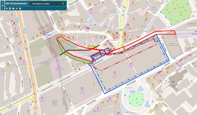
- The AIR processes
-
While the AIR conceptual framework provides information of what to consider when analysing the interfaces of transport infrastructure and its surrounding environment, there is a need for a standardised approach to its application. To assist the application of the AIR conceptual framework, therefore, the AIR processes were developed, tested, and refined, as part of the ongoing research.
This saw the creation of multi-disciplinary standardised approaches for:
- multi-disciplinary evidence-based source tool and data gathering (Fig.9);
- analysis of the interfaces between transport infrastructure and its environment (Fig.3);
- documentation of the evidence-based findings from the analysis, within an asset interface register (Table 1);
- verification (quality control) of the evidence-based findings (Fig.9);
- validation of the evidence-based findings by interfacing stakeholders (asset managers, owners, maintainers) (Fig.9);
- publication and sharing of diagrammatic data, representing the geographical presence of the interfaces (Fig.8);
- approaches to sharing and maintaining the findings across a transport infrastructure owning and maintaining organisation and with its interfacing stakeholders (Fig.10).
Fig.9: the AIR processes workflow showing the steps required to develop evidence-based data. Source: Darroch, Beecroft, and Nelson, 2020b
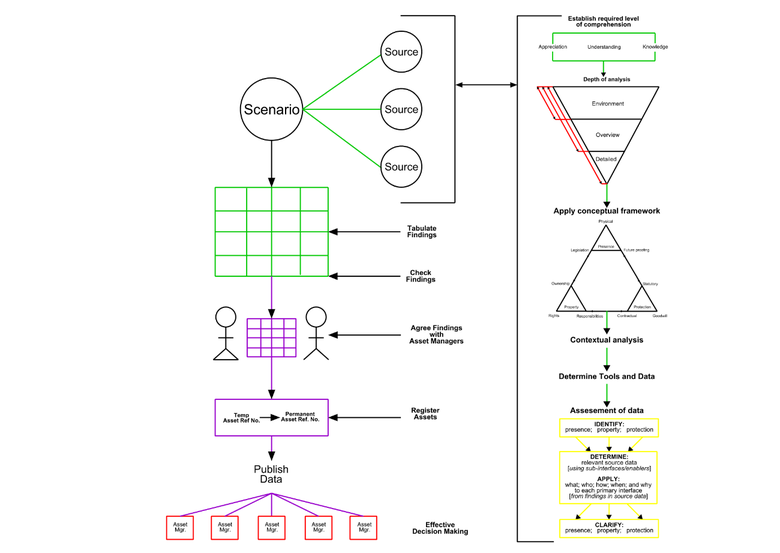
These approaches are represented by the AIR application workflow in Fig.9. The right-hand side of the workflow represents the processes of analysis of the interfaces; while the left-hand side represents the processes of multi-disciplinary data generation and sharing.
- On the right-hand side of the workflow are the approaches to:
- determining what level of consideration of the occurrences of the interfaces is required;
- depths of analysis for the interfaces, whether it is the:
- surrounding environment to the interfaces (environment (e.g. up to25m away) (environment);
- the immediate environment of the infrastructure forming the bridge and its approaches with the railway in Fig.8) (overview); or
- how assets forming the infrastructure interface with one another (e.g., the bridge, the road, and utilities within the road (detailed);
- by reference to the conceptual framework, relevant tools and data are gathered and employed to build the required level of comprehension for effective decision making enabling the management of the presence, property, and protection interfaces.
- On the left-hand side of the workflow are the approaches to:
- gathering references to source data (legal agreements, legislation, archive drawings/reports) from the multi-disciplinary analysis;
- documenting the key findings gathered from the analysis, within the asset interface register;
- ensuring that the data produced uses all pertinent data, it is spell checked, and accurately reflects the analysis (verification - quality control);
- validation of the key findings with all pertinent stakeholders to determine if the key findings represent accurate interpretations and practice;
- the sharing of finalised key findings within asset databases/BIM models;
- publication of the key findings within the AIR GIS, with links to the asset interface register and all other source archives or asset databases.
Fig.10: showing how the AIR processes form part of organisational business decision making for the effective management of the interfaces between transport infrastructure and its environemnt. Source: Darroch, Beecroft, and Nelson, 2020b
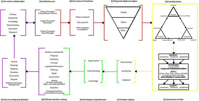
Fig.10 shows how the AIR processes form part of effective interface management within a transport organisation. The purpose of this workflow is to demonstrate how the conceptual framework can be incorporated within an interface decision-making process for stakeholders. Where an interface decision-making process is used to:
- determine the existing comprehension and data relative to the interfaces;
- determine how, when, and why the interfaces occur;
- generate accurate verified and validated data relative to the existing state, change, or management of the interfaces;
- develop an availability for generation of levels of comprehension for the interfaces;
- enable effective decisions based on the outputs of the analysis of interfaces;
- publish the documentation or records of those decisions and actions undertaken for future reference;
- work collaboratively with stakeholders, and other infrastructure owners to continue developing comprehension and data sharing, enabling more effective comprehension and decision making in future as the management of interfaces or their environment changes.
The workflow is broken down in to four coloured phases:
- Red – user applicability, to what depth of analysis does the user need to analyse data, relative to interfaces, based on available data;
- Yellow – application of the conceptual framework and its primary and its sub-inter-faces/enablers to archival data to identify and clarify the interfaces, with outputs docu-mented, verified, and validated;
- Green - comprehension from the depth of analysis enabling effective decision making to take place;
- Purple – documentation of decision-making, production and archiving of data (sources) to enable future decision making and pro-active collaboration between stakeholders.
- Benefits of employing the AIR processes
-
Through employing these processes, transport organisations and their interfacing stakeholders can achieve:
- organisational cost and time savings;
- the effective creation of, and amendment to, the interfaces between new transport infrastructure and its environment;
- the increased safe presence and operation of existing and proposed transport infrastructure and its environment;
- effective implementation of asset and urban management processes; and
- the development of effective sustainable transport and urban management policies and planning.
Fig.11: The AIR wheel, showing the interconnectivity of departments within a railway-based organisation and the standardised AIR processes for interface analysis and data sharing. Source: Darroch, Beecroft, and Nelson, 2020b

For example, Fig.11, shows the AIR wheel, which represents the need for multi-disciplinary evidence-based data sharing within a transport infrastructure owning and maintaining organisation, within the hub of the wheel are the AIR processes. Around the outside of the wheel are suggested departments and disciplines involved with the management of transport infrastructure and its environment. Each department/discipline generates data that are directly related to and are dependent on evidence-based data held and maintained by other departments. This interdependency is represented by the arrows pointing between the departments and the central hub of the wheel and the asset interface register.
- Outcomes from applying the AIR processes within participating organisations
-
Working collaboratively with participating organisations, the AIR research project will:
- determine the current processes of interface and asset data management, for the development of knowledge within participating organisations;
- apply and refine the AIR processes developed through previous practical and academic research, within participating organisations;
- develop a prototype asset interface register and GIS tool, based on a key case study area, through the application of the AIR processes to occurrences of the interfaces between transport infrastructure and its environment;
- evaluate the findings of the detailed case study to determine the benefits and limitations of the AIR processes to the organisation in enabling effective interface management of transport infrastructure and its environment;
- determine potential needs for amendment to existing organisational data to make it more effective;
- identify implications for current and future transport and urban policy and practice resulting from the employment of the AIR processes, within the participating organisation and internationally;
- offer further opportunities for development and implementation of AIR within the participating railway-based transport organisations, and subsequent potential for benchmarking with other transport and urban infrastructure management and construction organisations, globally;
- identify potential refinements of organisational, local, national, and international standards, policies, and procedures, for interface management, thus effecting sustainable management of transport infrastructure, its interfaces with its surrounding environment, and with the infrastructure of external stakeholders.
The following page presents a call for participation for railway-based organisations who would be interested in participating in the research.