B
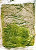
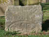
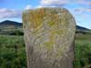
| Brandsbutt stone |
|---|
A class I Pictish symbol stone that may re-use a megalith from the stone circle that once stood here. 3 feet 6 inches high by 4 feet 2 inches wide by about 3 feet thick. It is re-assembled from fragments found in a dyke and some missing parts are substituted with cement. The south-east face bears the crescent and V rod and serpent and z rod symbols to the left of the symbols is an ogam inscription which reads IRATADDOARENS some part of which may be a version of the name Ethernan (as in St.Ethernan). |
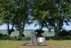
| Broomend of Crichie |
A class I Pictish Symbol stone located in the remains of a class II henge monument (a henge is defined by having a bank and ditch class II henges are those with two opposed entrances). The symbol stone was originally located on a bank 50 yards to the north-east and was moved when this bank was utilised as ballast during the construction of the adjacent railway line. It was probably a Pictish reuse of one of the megaliths that formed the avenue and the other stone circle mentioned below. It bears a 'Pictish Beast' symbol over a crescent and V rod. More Information |
C
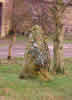
| Candle Stone |
|---|
A large very phallic standing stone 3.1 m high located just below a low summit, on a slope which shelves gently to the SE. More Information |
| Corsearder, Corsedarder or Corsedardar Stone |
A squarish block of reddish granite, about 4'7" in maximum height and 7' in girth, which was dug up many years before 1842 and was erected on top of the hill of Corsedardar, in the belief that it had marked the grave of some eminent person. The stone has been split, and now has the two portions set into a bed of concrete and pieced together by strong iron bands. Tradition says that it marks the spot where Dardanus, a Pictish king, was killed. A stone, 1.5m high, 0.8m wide, and 0.2m thick, generally as described, and possibly a cist slab. Visited by OS (R L) 12 June 1972. from RCAHMS |
| Corsedardar Long Cairn |

Remains of cairn; a curving scarp in the E probably represents the edge of the cairn in this quadrant; otherwise all that can be seen is turf-covered debris, insufficient to estimate the size and shape of the cairn. Part of it was dug into in c1860 when human remains and several silver coins were found. More Information |
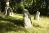
| Cothiemuir Stone Circle |

Also known as Devil's Hoofmarks, from some probable cup marks on the outer face of the recumbent The circle stones are of red granite. |
| Cullerlie Stone Circle |

In a fairly low-lying location, this circle consists of 8 rough boulders set in a circle 10.1 m in diameter. The circle contains eight small cairns, that showed signs of cremations, in some of the cairns were found burnt bone, charcoal, flint tools and a fragment of pottery. More Information |
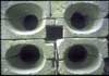
| Culsh souterrain or earth house |

Souterrains are a type of iron-age architecture that seems to have been fairly common in the area that is now Aberdeenshire, the most common assumption is that they were used for storage of grain and other food-stuffs. Souterrain curved and lined with dry stone walls (the walls have been mortared in modern times) and heavy roof slabs. Accessible but the visitor will require a torch to explore the few metres of passageway inside. |
D
| Deer Park standing stones, or the Druids |
|---|
A setting of three stones, older reports describe a fourth fallen stone. Variously described as standing stones or the remains of a circle. It appears to have been too small to be a Recumbent Stone Circle. More Information |
| Dunnideer, tower house and vitrified hill fort remains |
A dramatic hilltop ruin with stunning views over the surrounding countryside. More Information |
E
| Easter Aquhorthies RSC |
|---|

An impressive recumbent stone circle, 19.5 m in diameter, consisting of nine erect stones, the recumbent, two flankers and, in addition, two massive blocks which form a reserved area in front of the recumbent The circle is located near the crest of a hill shoulder, at 175 m OD. The characteristic differentiation between the recumbent with its flankers and the other circle stones can be seen vividly, both in terms of height of stones and their geological origin. The stones are graded in height from the 2.25 m tall flankers to the 1.7 m high stones on the circumference opposite, and, while the nine circle stones are of rough pinkish porphyry or (in the case of the second stone to the east of the flanker) a glowing red jasper, the flankers are of grey granite and the recumbent of reddish granite from near Bennachie. The outer face of the 3.8 m long recumbent has been smoothed carefully. The circle stones are set in a low bank. The very slight rise in the interior and a 1934 reference to a cist suggest the existence of a later ring cairn, now extremely vestigial. Its almost perfectly circular plan places this circle early in the series of recumbent stone circles More Information |
F
| Features at Dunnottar Castle |
|---|
The castle; probably occupies the site of a prehistoric fort. St Ninian established a church here about the beginning of the 5thC. It may also be the -Dunfoithir- besieged in 681. In the reign of William the Lion (1165-1214) -Dunnottar- was the place where warrants were returnable for the Mearns, and -le castiel de Dunostre- is mentioned at the beginning of the 13thC. Another castle was erected at the end of the 14thC. In its final form the castle was forfeited in 1716 and the roofs and floors removed and sold. In 1925 the systematic repair and excavation of the ruins was begun.In its present form the extensive remains date from various periods. The oldest portion is the early 15thC keep with a range of buildings extending to the E containing stables & storehouses. The gatehouse is approached by a steep path and defended by three tiers of splayed gun-loops. The arched entrance is the only opening on a solid wall of masonry set into a cleft in the rock; a very impressive and dominating entrance. The buildings to the NW grouped round a courtyard date from the late 16th or early 17thC, including a chapel. A huge water system lies within the courtyard. There is also a bowling green to the W of this later range. The Scottish Crown jewels (The Honours of Scotland) were hidden here in 1651 as it was considered one of the strongest places in the kingdom. In 1685 167 Covenanters were packed into a small vault, (the Whigs Vault) where 9 died due to the terrible conditions. Privately owned (Dunecht Estates) and open to the public. An oval motte was noted in 1970. More Information |
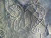
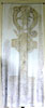
| Fetterangus Pictish Symbol Stone |
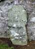
A class 1 symbol stone lies at the entrance to the graveyard of Fetterangus Church. It is of whinstone, 1.1m x 0.78m, and is much weathered, the carving is almost invisible to the naked eye, Near the top was a triple disc and bar or "cauldron" symbol below which was a rimmed "mirror case" its base containing opposed arcs with a palimpsest of another circular symbol overlapping it, at the bottom was a figure composed of a horizontal line and 2 curved lines one with a spiral end. Note some published descriptions are given with the stone the opposite way up to the above. Fairly clear photographs taken by Professor James Ritchie circa 1904 can be seen on the RCAHMS website (Archive Numbers: SC 676586, SC 676550, and SC1081353 the first stone shown on the linked page SC 676546 is another class 1 stone I cannot identify) follow the external link below . More Information |
| Fyvie 1 |
Fyvie Parish Church is at the east end of Fyvie, on the south side of the B9005. Set in the east wall of the church are three worn Pictish class I symbol stones, all have been trimmed. |
| Fyvie 2 |
Fyvie Parish Church is at the east end of Fyvie, on the south side of the B9005. Set in the east wall of the church are three worn Pictish class I symbol stones, all have been trimmed. |
G
| Gaval Stone |
|---|
Remains of recumbent stone circle; one remaining stone, impossible to say whether in situ or has fallen and been re-erected. The area of the circle, complete until about 1844, may have extended to the E of the stone. Apart from the stone, there is no trace of the other remains of the circle. |
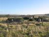
| Gravnie Braes Stone Circle |
Remains of a stone circle; five stones altogether, two standing and three lying in an arc. Surrounded by a distinct stone mound which may be the result of ploughing. One stone has fallen since 1961. More Information |
I
| Inverurie 3 and 2 |
|---|
Inverurie 3 is the lower part of a Class I Pictish slab showing most of a double disc and z rod symbol and what may be the lower part of a disc symbol. Inverurie 2 is a very small fragment showing part of an ornately patterned mirror symbol. As well as Inverurie 4 (the famous Inverurie Horse), Inverurie 1 is located in the same place but is too worn to photograph well. More Information |
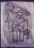
| Inverurie 4 |
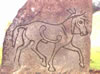
A class I Pictish stone showing a horse the only occurrence of the horse in symbol form although hunting scenes with horses and riders are a frequent element of class II stones. As with all Pictish Symbol stones dating is somewhat contentious. As the stone is somewhat eroded a superimposed drawing is included to show detail. As well as Inverurie 3 and 2, Inverurie 1 is located in the same place but is too worn to photograph well. More Information |
K
| Kintore 1 |
|---|
class I Pictish stone discovered underground in the churchyard (re used as a gravecover?). Now stands near the churchyard wall in a recess to the right of the entrance. |
| Kintore 4 |
A class I Pictish stone found in a garden in Kintore in 1974 at NJ790162 now in Inverurie museum it has a well executed Pictish beast and a rectangular symbol of which this is the only known occurence, also a plain mirror but no comb. More Information |
| Kirkton of Bourtie Recumbent Stone Circle |

The remains of this recumbent stone circle are situated in a cultivated field and comprise the recumbent, the E flanker, and two stones on the W arc. All the stones are of granite, the recumbent measuring 5.1m in length by 1.9m in height and 1.7m in thickness. The E flanker measures 2.9m in height by 1.45m in breadth and 1m in thickness. A large void beneath the E end of the recumbent has been filled in antiquity with a large boulder. The erect stones on the WSW and WNW of the circle measure 1.7m and 2.2m in height respectively. RCAHMS |
M
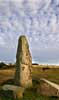
| Maiden Stone, Drumdurno |
|---|
Class II relief carved pink granite Pictish Symbol Stone, 3 metres 20 cm x 86 cm x 25cm. The symbols being the notched rectangle and Z rod and the Pictish Beast (A.K.A. elephant, dolphin) with a mirror and comb qualifier. East face has 4 panels. The top one has various beasts and a Pict headed centaur, The second panel the notched rectangle and Z rod, the third the Pictish Beast and the bottom panel the mirror and comb. |
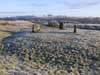
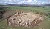
| Memsie Cairn |
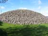
A very well preserved example of a larger round cairn, with no turf covering. Once part of a whole landscape of cairns that have been removed. The information board mentions some of the finds listed below (info from RCAHMS) but at this date it seems unclear where exactly particular artefacts were excavated and how accurate the descriptions of them were. The overall impression however is of a large important sacred site dedicated to funery rites over an extensive period of time. More Information |
| Midmar Recumbent Stone Circle |

The kirk yard contains a recumbent stone circle; This is a landscaped and slightly re-arranged recumbent stone circle, 17.3m in diameter; it consists of the recumbent, two flankers and five others. The two flankers, each c2.5m high (matched and shaped into two enormous canine teeth), flank a massive recumbent 4.5 m long which weighs some 20 tons it has some markings on the top. The present church was built in 1797 when the old church near Midmar was pulled down . The old graveyard continued in use until 1914 when the new one was laid out around the stone circle. It is likely that the ring cairn was tidied away, probably when the graveyard was laid out around the circle in 1914. Very well maintained |
| Migvie Class II Pictish Symbol Stone |
Class II Pictish Symbol Stone 180 x 70 x 38 cm. A low relief cross composed of coarse double interlace is carved in low relief on the east face from the angles of the arms and the top corners of the cross there are short projections ending in rings, which may represent hanging rings. In each quadrant is a symbol in very low relief. Upper left a small clumsy double disc and z rod, upper right even smaller horseshoe and v rod. To the lower right the remains of a mounted figure and two lower left a pair of shears the only known example of this symbol. On the reverse of the stone is a long haired horseman in low relief. This stone is striking by comparison to most Class II Pictish stones in the amateurishness of its execution. I can imagine a customer who could not come at the price demanded by a professional sculptor and instead commissioned a local handyman who was a bit out of his depth. The rider on the reverse seems much more accomplished perhaps a good stencil? More Information |
P
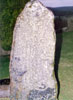
| Percylieu Stone |
|---|
Pictish class 1 stone with part of a Salmon and Horseshoe symbols. More Information |
| Picardy Stone, Myreton |
Class 1 Grey Whinstone Pictish Symbol Stone, 201cm x 102cm x 60cm. Three carved symbols on the south face, from top: Double Disc and Z-rod; Snake and Z-rod and a mirror. The stone stands on its original site, a low cairn, which is in a fenced enclosure, in front of the stone was a grave, this association makes this stone important to those who support the theory of symbol stones as memorials to dead individuals. More Information |
R
| Rhynie 5 |
|---|
A class I Pictish stone made of gabbro showing a 'double disc and z rod symbol' with a symbol variously interpreted as a dog's head or as a mask made from the skin of a hind, accompanied by the mirror and comb regarded as a qualifying symbol. As with all Pictish Symbol stones dating is somewhat contentious. There are cup marks on the back of the stone suggesting Pictish re-use of a stone made significant in the Neolithic. Two other fragmentery stones, Rhynie 6 and 8, are at the same location. In all 8 symbol stones are known from Rhynie (suggesting a site of major importance) including the 'Rhynie Man' carving 7. Rhynie 4 has been broken up and lost, Rhynie 1 'The Craw Stane' is in situ 2 and 3 stand in the village sqare but their carving is now illegible to the human eye. More Information |
| Rhynie 6 |

A fragment of a class I Pictish stone made of pink granite the very bottom of a vertical double disc and Z rod can just be seen above a plain crescent and V rod and a mirror. Two other stones, Rhynie 5 and the fragmentery 8, are at the same location. In all 8 symbol stones are known from Rhynie (suggesting a site of major importance) including the 'Rhynie Man' carving 7. Rhynie 4 has been broken up and lost, Rhynie 1 'The Craw Stane' is in situ 2 and 3 stand in the village sqare but their carving is now illegible to the human eye. More Information |
| Rothiebrisbane Symbol Stone |
Fyvie Parish Church is at the east end of Fyvie, on the south side of the B9005. Set in the east wall of the church are three worn Pictish class I symbol stones, all have been trimmed. |
S
| St Colms Well Portsoy |
|---|
Rubble built tunnel type entrance, the well is said to have been built in the early part of the 7th century. The well 2ft diameter, and still flowing, is now covered by a stone cupola with an arched entrance. The well is hidden away in an earth mound (Perhaps a burial mound since it is adjacent to the cemetery) You can only see the well if you actually enter the cemetery by the gate at the bottom of the hill opposite the caravan for the warden of the caravan site. The plaque, made from the soft unstable yellow sandstone of the area, is just recognisable as St Colm's well but will be lost soon, the plaque dates from when the well was restored in 1893 though the date is now hardly readable. |
| St. Marnochs Chair, Marnoch |
Two stones surviving from a stone circle More Information |
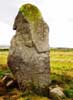
| Stone of Morphie, Alternative Name: Stone Of Morphy |
Stone of Morphie: This standing stone (measuring 1m by 0.7m at the base and 3.4m in height) is immediately S of the public road in the stackyard of Stone of Morphie farm. Traditionally said (New Statistical Account [NSA] 1845) to mark the grave of a son of Camus, killed in a battle between the Scots and the Danes, it was knocked down shortly before 1856. Digging prior to re-erection revealed part of a human skeleton, buried in black unctuous earth. The stone is freestone, and is uninscribed. as ref RCAHMS 1982; J Stuart 1856; Name Book 1863 More Information |
| Strichen Recumbent Stone Circle also known as Strichen House Stone Circle |
An atmospheric, restored, Buchan recumbent stone circle 13.5 meteres in diameter. The site has good views to the North-East of Mormond and Waughton Hill, and the White Horse, also overlooks the ruins of Strichen House. Currently (2005) a little overgrown with gorse More Information |
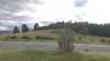
| Sunhoney Recumbent Stone Circle |

The monument is very well preserved recumbent stone circle, 25m - 26.7 in diameter, lying in an area bounded by a 19th-century plantation wall. The circle comprises 11 standing stones and the recumbent. The recumbent and one of the uprights bear cupmarks. Within the circle is a raised platform measuring some 7m across, probably the remains of a ring cairn. The circle is on a hilltop surrounded by trees above Sunhoney farm. |
T
| Tarlair and environs |
|---|
Tarlair – Art Deco outdoor swimming pool and boating pond opened in the 1930’s, it was once very popular with tourists, now falling into disrepair, no swimming allowed any more, disused since 1995, currently only used by model boat owners. Classified ‘A’ listed in 2007 by Historic Scotland. |
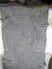
| The Craw Stane (Rhynie 1) |
Class I Pictish symbol stone. The stone faces south it is a large stone 180cm by 102cm by 43cm. It has near the top a large Salmon symbol above a Pictish beast. It stands at one side of the inner entrance to an almost imperceptable (but clear in ariel photgraphs of crop marks) multi-vallate circular enclosure crowning the end of a low spur. It could possibly have been a structural feature re-used in situ as a symbol stone. More Information |
| The Raven Stone |
A class one Pictish stone showing the Sea Eagle and notched rectangle with z rod symbols the black infill is recent. As with all Pictish Symbol stones dating is somewhat contentious. The name 'The Raven Stone' probably originated as the result of a mistaken association of the stone and a nearby burial mound (in the manse garden) by the antiquarians of the past with Danish invaders. More Information |
| The Wolf Stone |

Pictish Class 1 stone bearing the rectangle symbol sometimes described as a book case and a wolf, plus the mirror and comb symbol. More Information |
| Tomnaverie (Tarland) Stone Circle |
The recumbent stone circle is a form unique to North East Scotland. |
This content was submitted by external contributors and does not necessarily reflect the views of the University of Aberdeen.