We're looking for photographs that show water level during the flood that retain the time-stamp (photographs taken by smartphones and most digital cameras generally include information on the time, date, and sometimes place, that the photo was taken.
We're concentrating on the area either side of Aboyne Bridge BUT in the future we'd like to include studies elsewhere along the Dee during Storm Frank - from Banchory to Braemar for the Dee and its side streams. So we'd welcome any time-stamped photography of before the flood, DURING the flood, and after the flood. Our aim is to crowd source multiple photos of the same location taken at different times.
To email us your photos please click on the link on the right.
Crowd-Sourcing the Hydrograph
A hydrograph is a plot of water-level through time, for a single location. In general the data for these charts come from gauges in permanent monitoring stations mounted along rivers. But every photograph of a river carries information on water-level and can be used to reconstruct changing levels if we know the time (hours, minutes) that the photograph was taken - and can match the water-level on the photo to known objects (trees, buildings, telegraph poles, road surfaces etc.). We will calibrate the elevation of objects using a high-resolution survey.
We are also interested in photographs of the build-up of wood and debris around the bridge during and after the flood, and the patterns of sediment deposited.
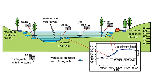
In the diagram above a cross section shows the normal river level and how we might determine the river height at different times. If we source enough photography we can build up a 3D hydrograph upstream and downstream from the bridge.
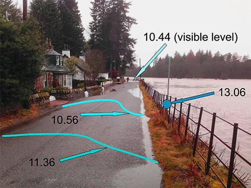
The annotated photograph below shows the water level on the Birse side of the Aboyne Bridge at 10.44am - it is visible on the road by the motorbike. The other lines are annotated water levels on the road at different times 10.56am and 11.36am (as established from other photographs). The blue dot marks the height of the water on the fence at 13.06.
Email Your Photographs to Us
Please click on the link below to send us an email containing the information we require:
![]()
If your email program doesn't support using the the button above please simply email your photographs to deeflood@abdn.ac.uk and include the following information:
- Your Name:
- When the Photograph(s) were taken:
- Where the Photograph(s) were taken:
- If you are willing to let us reproduce your photos please type yes:
Please note:
- the maximum combined size of attachments you will be able to send is 25MB. If your photographs exceed this please send using more than one email. Or if you have lots of photographs contact us to set up an alternative method of exchange.
- In sending your photographs to us you are confirming you are either the owner of the image or have the image owner's permission to send them to us. We will use your photos purely to derive data for our modelling. If you would like to give us permission to reproduce your images please indicate this as noted above.
- If you agree to let us reproduce your photos you grant us a royalty-free, non-exclusive licence to publish and otherwise use the material in any way that we want. This is likely to be as examples in research presentations and on our webpages. It's important to note, however, that you still own the copyright to everything you contribute and that if your image is used, we will endeavour to publish your name alongside it.
Thank you for taking part in our research we will update the webpages with results as we get them.